Another weekend, another hike! We decided to start from a familiar spot not far from home. CT Trail Section 18 begins at Penwood State Forest and offers a number of trails, some of which we'd hiked before.
Our foible of the day came after trusting our GPS. This time both of them were wrong. Since we'd been to Penwood before, we KNEW that when the GPS announced we'd "reached our destination," we were not in the right place. We were on a side road marked with a sign that read "Private Property." Still, we kept going, because maybe this was a back way we weren't aware of, or something like that? We saw more No Trespassing signs and then the clincher, a last sign that boldly asserted: "Turn Around. GPS Incorrect." At that point we'd reached a house far set back down this road and had to turn around in a driveway where a man with a dog were glaring at us. Apparently we weren't the only ones who had done this.
So after trusting our memories rather than the GPS, we ended up in correct parking lot about a mile down the road. Within a short period we had turned from the pleasantly paved road that starts the trail and took a sharp left turn up the steep hill.
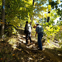
Thankfully after an initial incline the trail evened out or climbed more gradually, winding through trees that were just showing the very first hints of color. The first part of the trail, if you're headed south to north, is very well traveled, as it's a really popular spot with locals.
We noticed a number of rock formations, large boulders, and even an interesting large collection of smaller rocks where people had left their mark by leaving their own specially crafted cairns. The kids took a moment to build their own.
The trail levels out for awhile and comes to a point where several different trails connect near Lake Louise (it's more like a small pond, to be accurate). There's a nice little viewing platform to look out at the lake. Unfortunately, there was a man who had chosen to sit right at the edge in the best spot to meditate or something of that nature, so it was hard to spend any time capturing too many photos. I am not sure how he found it peaceful there when people were constantly walking up and around him to look out across the lake. This was a Saturday afternoon in the fall after all, so I hope he didn't expect to have the place to himself.
From there the trail grows perhaps a little less interesting, but blessedly quieter. It's not that I hate people. But anyone that enjoys hiking for any extended period of time has to also have a healthy appreciation for solitude.
The trail eventually peeks out to some nice views along the ridgeline, looking west and south. There are some convenient flat ledges (not too close to the edge) to spread out and have some lunch or a snack. We stopped for a water break and were on our way.
Every hike we do, it seems as if once we get about four miles in, that's when the kids start complaining. It's not really bad -- more like a "my feet hurt" or "how much longer is this going to take?" but it seems to happen like clockwork. It helps if there are points of interest along the trail, something out of the ordinary. For a while this was a pretty standard walk in the woods. But in the end the trail did not disappoint.
At one point we came out of the woods and crossed under our familiar friends the power lines, where there was a big flat rock calling out to us to sit down and have a snack.
Back in the woods, we noticed that the trail kept straddling the border of the towns of Bloomfield and Simsbury, as we continually crossed past signs like these. The ridge line must be the border between the two towns.
This was a six-mile hike, and just as everyone was starting to lose steam near the end, we saw something up ahead of us set back a few steps off the trail and behind some trees. Curious, we pushed further and had to turn off slightly to check it out.
It turned out to be a huge chimney, much larger than any typical house chimney ruins we'd come across in the woods before. As we wondered just what what the story was behind it, we saw something peeking out from around the back. It was plastic bag filled with notes and little trinkets. This was a geocache spot, and someone had come up with a super cool hiding place. We left things as they were for the next geocacher and continued the quarter mile or so to the end of the trail -- which came out right in the spot where we'd started our hike on Section 19 the week before.
Later we delved into the history of the spot and were able to put the pieces together. The chimney was actually part of the Bartlett's Tower Resort in the late 1800s that stood 70 feet high and included guest bedrooms and an observation deck. The tower was later turned into a private retreat and was destroyed by fire in 1936. You can
read more about Bartlett's Tower here.
Learning the history of this place was fascinating -- especially as we'd never heard of the tower and would have never heard of it if we hadn't come about it in the woods. When hiking it's good to always keep your eyes and ears open, staying in the right now, and keeping curious. Thankfully the internet makes it easier than it ever has been to find out more about the places you're seeing and all of the history that has gone before you.
This was another fun hike because again, there was a little bit of everything. Aside from a couple of steep areas that don't last too long, it's not extremely challenging, either, without as much ledge walking to make parents of younger children a little anxious. There were also no surprise hills near the end to drain your spirits! After our adventures on CT Section 18, I think we all were starting to get into the spirit of looking for what the next adventure held for us.


Comments
Post a Comment